
Page 362 - Çevre Şehir İklim İngilizce - Sayı 4
P. 362
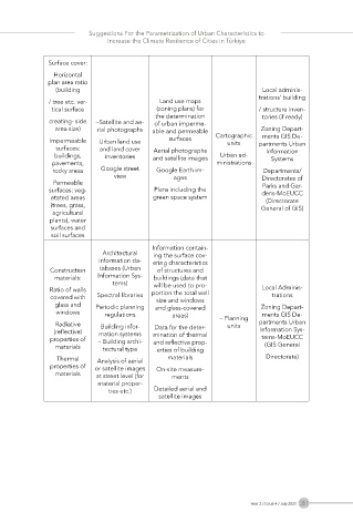
Suggestions For the Parametrization of Urban Characteristics to
                             Increase the Climate Resilience of Cities in Türkiye


             Surface cover:
               Horizontal
             plan area ratio
               (building                                            Local adminis-
                                                                    trations’ building
              / tree etc. ver-            Land use maps
              tical surface              (zoning plans) for         / structure inven-
                                         the determination          tories (if ready)
              creating- side   –Satellite and ae-  of urban imperme-
               area size)  rial photographs  able and permeable     Zoning Depart-
                                                                    ments GIS De-
              Impermeable   Urban land use   surfaces   Cartographic   partments Urban
                                                           units
               surfaces:   and land cover   Aerial photographs       Information
               buildings,   inventories  and satellite images  Urban ad-  Systems
              pavements,                                 ministrations
               rocky areas  Google street   Google Earth im-         Departments/
                              view            ages                  Directorates of
               Permeable                                            Parks and Gar-
              surfaces: veg-             Plans including the        dens-MoEUCC
              etated areas              green space system           (Directorate
              (trees, grass,                                        General of GIS)
               agricultural
              plants), water
              surfaces and
              soil surfaces
                                        Information contain-
                           Architectural   ing the surface cov-
                          information da-  ering characteristics
              Construction   tabases (Urban   of structures and
               materials:  Information Sys-  buildings (data that
                              tems)     will be used to pro-
              Ratio of walls            portion the total wall      Local Adminis-
              covered with   Spectral libraries  size and windows      trations
               glass and   Periodic planning   and glass-covered    Zoning Depart-
               windows      regulations      areas)                 ments GIS De-
               Radiative   Building infor-  Data for the deter-  – Planning  partments Urban
                                                           units
               (reflective)   mation systems   mination of thermal   Information Sys-
              properties of   – Building archi-  and reflective prop-  tems-MoEUCC
               materials   tectural type  erties of building         (GIS General
                Thermal   Analysis of aerial   materials             Directorate)
              properties of   or satellite images   On-site measure-
               materials  at street level (for   ments
                          material proper-
                             ties etc.)  Detailed aerial and
                                          satellite images


                                                                 Year 2 / Issue 4 / July 2023  351