Page 358 - Çevre Şehir İklim İngilizce - Sayı 4
P. 358
Suggestions For the Parametrization of Urban Characteristics to
                             Increase the Climate Resilience of Cities in Türkiye

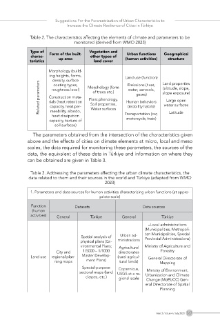
             Table 2. The characteristics affecting the elements of climate and parameters to be
                                monitored (derived from WMO 2023)

              Type of                 Vegetation and
              charac-  Form of the built-  other types of   Urban functions   Geographical
             teristics   up area        land cover   (human activities)  structure

                     Morphology (build-
                     ing heights, forms,             Land use (function)
                       density, surface   Morphology (form   Emissions (heat,   Land properties
                 Related parameters  Construction mate-  Plant phenology,   Human behaviors   slope exposure)
                       coating types,
                                                                    (altitude, slope,
                                                      water, aerosols,
                      roughness level)
                                       of trees etc.)
                                                         gases)
                                                                      Large open
                     rials (heat retention
                                      Soil properties,
                                                                     water surfaces
                      capacity, heat per-
                                                      (mobility habits)
                      meability, albedo,
                      heat dissipation   Water surfaces  Transportation (car,   Latitude
                     capacity, texture of            motorcycle, train)
                        soil surfaces)
               The parameters obtained from the intersection of the characteristics given
            above and the effects of cities on climate elements at micro, local and meso
            scales, the data required for monitoring these parameters, the sources of the
            data, the equivalent of these data in Türkiye and information on where they
            can be obtained are given in Table 3.
              Table 3. Addressing the parameters affecting the urban climate characteristics, the
             data related to them and their sources in the world and Türkiye (adapted from WMO
                                            2023)

              1. Parameters and data sources for human activities characterizing urban functions (at appro-
                                          priate scale)
              Function          Datasets                    Data sources
              (human
              activities)  General    Türkiye      General          Türkiye
                                                              –Local administrations
                                                             (Municipalities, Metropoli-
                                  Spatial analysis of   Urban ad-  tan Municipalities, Special
                                                             Provincial Administrations)
                                  physical plans (En-  ministrations
                                  vironmental Plans;   Agricultural   Ministry of Agriculture and
                        City and   1/5000 – 1/1000   directorates   Forestry
              Land use  regional plan-  Master Develop-  (rural agricul-  General Directorate of
                       ning maps     ment Plans)  tural lands)     Mapping
                                   Special-purpose   Copernicus,
                                  sectoral maps (land   USGS at a re-  Ministry of Environment,
                                    classes, etc.)  gional scale  Urbanization and Climate
                                                             Change (MoEUCC) Gen-
                                                             eral Directorate of Spatial
                                                                   Planning


                                                                 Year 2 / Issue 4 / July 2023  347

