
Page 361 - Çevre Şehir İklim İngilizce - Sayı 4
P. 361
Süleyman Toy - Zeynep Eren
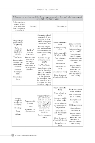
2. Data sources (at micro-scale) identifying the parameters that describe the built-up, vegetat-
ed and other land cover types
Built-up surfaces,
vegetated sur-
faces and other Datasets Data sources
land cover types
(urban form)
Calculation of wall
areas with data to
be obtained from
Morphology building/structure
(elements of inventories (if any) Urban administra-
roughness): tions Local administra-
Building heights tions’ building
Wall area and distances with Urban planning
density or Building/ the data to be ob- units / structure inven-
façade area structure tained from zoning Units responsible tories (if ready)
density inventories plans for urban parks Zoning Depart-
View factors Derived from Satellite images Tree-advocacy ments GIS De-
the ratio of partments Urban
Distance be- and aerial photo- groups Information Sys-
tween rough- the heights graphs tems
and spans
ness elements (distances) of Sky View Factor (vegetation)
(distance Transportation Departments/
the roughness Spatial data to be Directorates of
between elements. used in the calcu- units Parks and Gar-
buildings/ lation of the ratio (road/street trees) dens-MoEUCC
trees) of building heights City and regional (Directorate Gen-
Street direc- to the distance planning GIS units eral of GIS)
tions between buildings
for identification of
the areas that may
be urban canyons.
Urban administra-
tions Local administra-
tions’ building
Urban planning
units / structure inven-
Images and zoning tories (if ready)
Height; plan information Units responsible
Height of Stereographic that can be used for urban parks Zoning Depart-
roughness images to find the heights Groups advocat- ments
elements: of buildings, trees ing green spaces GIS Departments
LIDAR and other urban
Buildings elements that (vegetation) Urban Informa-
Synthetic-Ap- provide vertical tion Systems
Transportation
Trees erture Radar elevation units (road/street
Others trees) Departments/
On-site measure- Directorates of
ments City and regional Parks and Gar-
planning GIS units dens-MoEUCC
(Directorate Gen-
- Central institu- eral of GIS)
tions
350 The Journal of Environment, Urban and Climate