Page 364 - Çevre Şehir İklim İngilizce - Sayı 4
P. 364
Suggestions For the Parametrization of Urban Characteristics to
                             Increase the Climate Resilience of Cities in Türkiye


                3. Data sources used to determine the parameters describing functions (at local scale)
              Function (Hu-  Datasets                 Data sources
             man activities)
                                                   Urban administrations
                                                   Agricultural units (rural   –Local adminis-
                            City and                  production)       trations
                          regional plan-  Spatial ana-
                           ning maps  lyzes of physi-  https:// land.coper- nicus.  Zoning De-
                          CORINE land   cal plans (En-  eu/ pan-euro- pean/cori-   partments GIS
                                                                      Directorates
                                                     ne-land-co- ver
               Land use    cover data   vironmental
                            (Europe)  Plans; 1/5000   https:// land.coper- nicus.  Urban Informa-
              / urban func-           – 1/1000 Mas-  eu/ global/con- tent/  tion Systems
             tions (industry,   Copernicus   ter Develop-  annu- al-100m-glo- bal-
              trade, hous-  Global Land   ment Plans)                  – MoEUCC
                 ing)       Cover                 land-co- ver-maps-a- vail-  Directorate
                                                         able
                                       Aerial and                      General of
                          USGS maps   satellite pho-  https://www.usgs. gov/  Geographic
                          LCZ (local cli-  tographs  sear- ch?keyword-   Information
                          mate zones)               ds=Land%20 Cover  Systems (Urban
                                                 https://www.wudapt. org/  Digital Twins)
                                                       lcz-maps/
                                     Fuel oil (petrol
                                     – LPG) use (for
                                       motor vehi-
                                         cles)
                                                                         EPDK
                                       Natural gas
                           Statistical   use (Industrial              Local natural
                             data:    and domestic                    gas and elec-
                          Energy con-   heating)  National, regional, urban   tricity distribu-
                                                       data sets
             Anthropogen-  sumption                                  tion companies
                                        Coal use
              ic heat emis-            (Industrial                       OIZs
                 sion     Housing types
                                      and domestic   National and regional   Local Adminis-
                          Building ther-  heating)   statistical offices  trations TURK-
                          mal insulation                                 STAT
                             status   Electricity use
                                      (Industrial and                 Building/struc-
                                       domestic)                     ture inventories
                                       Number of
                                       energy-effi-
                                     cient buildings
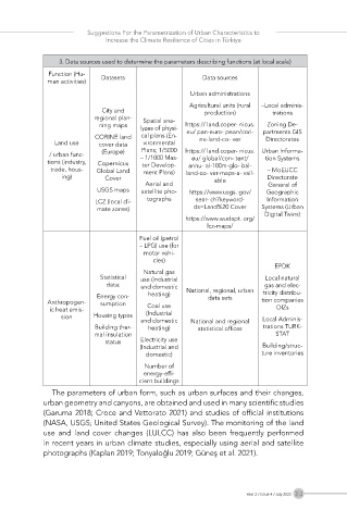
               The parameters of urban form, such as urban surfaces and their changes,
            urban geometry and canyons, are obtained and used in many scientific studies
            (Garuma 2018; Croce and Vettorato 2021) and studies of official institutions
            (NASA, USGS; United States Geological Survey). The monitoring of the land
            use  and  land  cover  changes  (LULCC)  has  also  been  frequently  performed
            in recent years in urban climate studies, especially using aerial and satellite
            photographs (Kaplan 2019; Tonyaloğlu 2019; Güneş et al. 2021).


                                                                 Year 2 / Issue 4 / July 2023  353

