Page 363 - Çevre Şehir İklim İngilizce - Sayı 4
P. 363

Süleyman Toy - Zeynep Eren


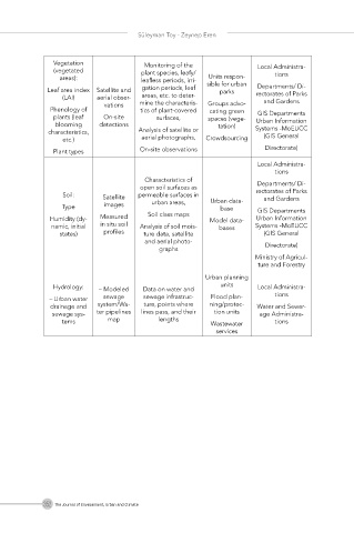
               Vegetation             Monitoring of the            Local Administra-
               (vegetated            plant species, leafy/             tions
                                                      Units respon-
                areas):              leafless periods, irri-  sible for urban
                                                                   Departments/ Di-
             Leaf area index  Satellite and   gation periods, leaf   parks  rectorates of Parks
                 (LAI)    aerial obser-  areas, etc. to deter-       and Gardens
                            vations  mine the characteris-  Groups advo-
              Phenology of           tics of plant-covered   cating green
                                                                   GIS Departments
               plants (leaf   On-site    surfaces,    spaces (vege-  Urban Information
               blooming   detections                     tation)
             characteristics,        Analysis of satellite or     Systems -MoEUCC
                                                                     (GIS General
                 etc.)               aerial photographs,  Crowdsourcing
               Plant types           On-site observations            Directorate)
                                                                   Local Administra-
                                                                       tions
                                      Characteristics of           Departments/ Di-
                                     open soil surfaces as
                 Soil:     Satellite   permeable surfaces in   Urban data-  rectorates of Parks
                                                                     and Gardens
                 Type       images      urban areas,     base      GIS Departments
              Humidity (dy-  Measured   Soil class maps  Model data-  Urban Information
              namic, initial   in situ soil   Analysis of soil mois-  bases  Systems -MoEUCC
                states)     profiles  ture data, satellite           (GIS General
                                      and aerial photo-              Directorate)
                                          graphs
                                                                  Ministry of Agricul-
                                                                   ture and Forestry
                                                      Urban planning
               Hydrology:  – Modeled  Data on water and   units    Local Administra-
              – Urban water  sewage   sewage infrastruc-  Flood plan-  tions
              drainage and  system/Wa-  ture, points where   ning/protec-  Water and Sewer-
              sewage sys-  ter pipelines   lines pass, and their   tion units  age Administra-
                 tems        map          lengths      Wastewater      tions
                                                        services


            352 The Journal of Environment, Urban and Climate
   358   359   360   361   362   363   364   365   366   367   368