Page 357 - Çevre Şehir İklim İngilizce - Sayı 4
P. 357
Süleyman Toy - Zeynep Eren


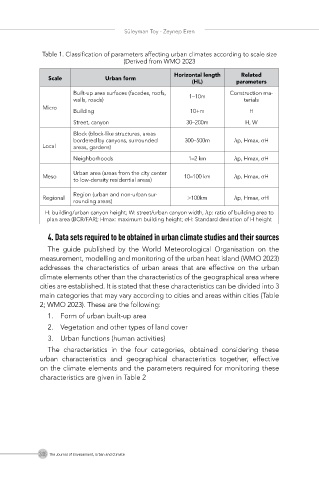
             Table 1. Classification of parameters affecting urban climates according to scale size
                                    (Derived from WMO 2023

                                                   Horizontal length   Related
               Scale           Urban form
                                                        (HL)        parameters
                      Built-up area surfaces (facades, roofs,   1–10m  Construction ma-
                      walls, roads)                                   terials
             Micro
                      Building                         10+m             H
                      Street, canyon                  30–200m          H, W
                      Block (block-like structures, areas
                      bordered by canyons, surrounded   300–500m    λp, Hmax, σH
             Local    areas, gardens)

                      Neighborhoods                    1–2 km       λp, Hmax, σH
                      Urban area (areas from the city center
             Meso                                    10–100 km      λp, Hmax, σH
                      to low-density residential areas)
                      Region (urban and non-urban sur-
             Regional                                 >100km        λp, Hmax, σH
                      rounding areas)
              H: building/urban canyon height; W: street/urban canyon width, λp: ratio of building area to
              plan area (BCR/FAR); Hmax: maximum building height; σH: Standard deviation of H height

               4. Data sets required to be obtained in urban climate studies and their sources
               The  guide  published  by  the  World  Meteorological  Organisation  on  the
            measurement, modelling and monitoring of the urban heat island (WMO 2023)
            addresses  the  characteristics  of  urban  areas  that  are  effective  on  the  urban
            climate elements other than the characteristics of the geographical area where
            cities are established. It is stated that these characteristics can be divided into 3
            main categories that may vary according to cities and areas within cities (Table
            2; WMO 2023). These are the following:
               1.  Form of urban built-up area
               2.  Vegetation and other types of land cover
               3.  Urban functions (human activities)
               The  characteristics  in  the  four  categories,  obtained  considering  these
            urban  characteristics  and  geographical  characteristics  together,  effective
            on the climate elements and the parameters required for monitoring these
            characteristics are given in Table 2


            346 The Journal of Environment, Urban and Climate

