
Page 25 - Çevre Şehir İklim İngilizce - Sayı 4
P. 25
Aliye Ahu Gülümser - Nur Kardelen Öztürk - Mert Akay - Burak Belli
zones. In this way, fault avoidance zone criteria will be determined and it will
be ensured that the construction around active faults and planning decisions
will be kept under control; and these criteria will be applied in all active fault
zones in our country. The risks of natural disasters such as avalanches and
landslides, primarily the earthquakes are observed together in the eastern
regions of Türkiye, in particular. It is aimed to reveal the existing building stock
at risk in these settlements by conducting analyses for settlements exposed to
natural disaster hazards.
One of the actions in SSP of Türkiye related to urban transformation is
“02.02.01 Urban development will be ensured, which is resilient to disaster
risks including primarily earthquake, overflow, landslide, flood, drought etc.”
under the Strategy 02.01. Within the scope of this action, urban risky areas
will be defined depending on holistic risk analyses and it will be integrated
with spatial planning in accordance with these definitions. Until 2030,
comprehensive strategies will be developed in the direction of improvement,
renovation and transformation in these defined areas.
An integrated disaster risk assessment was performed for determining the
priority areas of action for the strategic goal of resilience to disaster risks of
the SSP of Türkiye. Integrated risk assessment based on earth science data in
our country, where major disasters have occurred, is an important requirement
for local disaster risk management and the construction of sustainable cities
and societies (Okay, 2021). With the integrated approach developed with the
help of geographical information systems, it was attempted to ensure natural
hazards to take on a guiding role in spatial planning. This approach, which is
also compatible with the UN Sustainable Development Goals, is considered
to be directly related to SDGs 9, 11 and 13. These goals are related to the
construction of infrastructure and technological solutions that are resistant to
disaster risks, sustainable healthy urbanization and adaptation to the effects
of climate change.
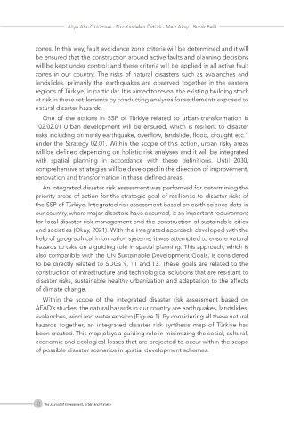
Within the scope of the integrated disaster risk assessment based on
AFAD’s studies, the natural hazards in our country are earthquakes, landslides,
avalanches, wind and water erosion (Figure 1). By considering all these natural
hazards together, an integrated disaster risk synthesis map of Türkiye has
been created. This map plays a guiding role in minimizing the social, cultural,
economic and ecological losses that are projected to occur within the scope
of possible disaster scenarios in spatial development schemes.
10 The Journal of Environment, Urban and Climate