
Page 248 - Çevre Şehir İklim İngilizce - Sayı 3
P. 248
Evaluation of Surface Runoff Risk in The Frame of Landscape Pattern:
The Case of Kastamonu Central District
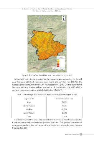
Figure 8. The Surface Runoff Risk Map created according to AHP.
In line with the criteria selected in the research area according to the risk
map, the areas with high risk have been found at a very low rate (0.03%). The
highest value was found in medium-risky areas by 43.24%. On the other hand,
the areas with the lower-medium level risk took the second place (45.63%) in
terms of the percentage of spatial distribution (Table 7).
Table 7. Percentage distributions of areas according to the degree of risk:
Degree of risk Share in the entire area
High 0.03%
Above medium 1.53%
Medium 43.24%
Lower Medium 42.63%
Low 12.57%
It is observed that the areas with a medium risk level are mostly concentrated
in the southern and southeastern parts of the area. This part of the research
area corresponds to the part where the altitude and slope degrees increase
(Figures 2 and 6).
Year 2 / Issue 3 / January 2023 233