
Page 200 - Çevre Şehir İklim İngilizce - Sayı 2
P. 200
Designing Resilient Cities: Application
Guide Seeking, The Case Of İzmir Torbalı
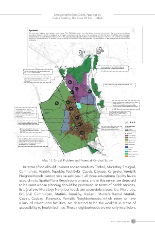
Synthesis
The area has highway and railway connections. The IZBAN line in the area facilitates access to the district. Torbalı is close to Adnan
Menderes Airport, which increases the strategic importance of the area. The junctions on the E87 and D550 highways facilitate
transportation. It was detected that most of the agricultural land in the district consists of alluvium. Alluvium soil is deep, permeable
and rich in plant nutrients, so there is a crop diversity in the district. The disorganized industrialization in the area causes environmental
problems.
In the agricultural land, all kinds of grains,
industrial plants and fruits and vegetables
are grown
Cemer City Equipment in İstiklal Neighborhood
has a power of GES 0.40 MW
The Granite Durable Consumption Solar Power
Plant in Yazıbaşı Neighborhood has a power
of 0.38 MW
There are olive groves in the outskirts of the mountains. The
mountains are covered with pine trees.
Reysaş Logistical Solar Power Plant has a power
of 0.81 MW. The largest amount of energy
production in the district is generated here.
This constitutes a great potential for renewable
energy use.
Torbalı Waste Water Treatment
Facility purifies the water of Torbalı
town center, Subaşı, Çaybaşı, Gazi Mustafa Kemal Neighborhood is
Pamukyazı, Yeniköy, Özbey, Arslanlar, largely made up of 6-floor buildings in
Şehitler, and the settlements close adjacent formation.
to the center.
Torbalı District is largely made up of
6-floor buildings in adjacent formation.
District border
Rivers
Muratbey Neighborhood is made Higway
up of 3-4 floor buildings in adjacent 1st degree road
formation. 2nd degree road
Railway
Industrial Region
Settlement Areas
The Torbalı Waste Water Treatment Facility in
Muratbey Neighborhood, purifies the water of Agricultural land
Torbalı town center, Subaşı, Çaybaşı, Pamukyazı, Alluvium land
Yeniköy, Özbey, Arslanlar, Şehitler, and the
settlements close to the center. Colluvial land
Education
Health
Religious institutions
Parks and Green Areas
Social Facilities
Map 13: Torbalı Problem and Potential (Original Study)
In terms of social build up areas and accessibility, Torbalı, Muratbey, Ertuğrul,
Cumhuriyet, Atatürk, Tepeköy, Yedi Eylül, Çapak, Çaybaşı, Karşıyaka, Yemişlik
Neighborhoods cannot receive services in all three educational facility levels
according to Spatial Plans Regulations criteria, and in this sense, are detected
to be areas whose planning should be prioritized. In terms of health services,
Ertuğrul and Muratbey Neighborhoods are accessible places, but Muratbey,
Ertuğrul, Cumhuriyet, Atatürk, Tepeköy, Alpkent, Mustafa Kemal Atatürk,
Çapak, Çaybaşı, Karşıyaka, Yemişlik Neighborhoods, which seem to have
a lack of educational facilities, are detected to be the weakest in terms of
accessibility to health facilities. These neighborhoods are not only insufficient
Year 1 / Issue 2 / July 2022 186