
Page 190 - Çevre Şehir İklim İngilizce - Sayı 2
P. 190
Designing Resilient Cities: Application
Guide Seeking, The Case Of İzmir Torbalı
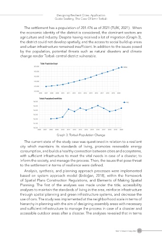
The settlement has a population of 201.476 as of 2021 (TUİK, 2021). When
the economic identity of the district is considered, the dominant sectors are
agriculture and industry. Despite having received a lot of migration (Graph 3),
the district could not develop spatially, and the access to social build up areas
and urban infrastructure remained insufficient. In addition to the issues posed
by the population, potential threats such as natural disasters and climate
change render Torbalı central district vulnerable.
Tobalı Population Graph
Torbalı Population Growth Rate
Graph 3: Torbalı Population Change
The current state of the study case was questioned in relation to a resilient
city which maintains its standards of living, promotes renewable energy
consumption, and builds a healthy connection between cities and ecosystems,
with sufficient infrastructure to meet the vital needs in case of a disaster, to
inform the society, and manage the process. Then, the issues that pose threat
to the settlement in terms of resilience were defined.
Analysis, synthesis, and planning approach processes were implemented
based on system approach model (Erdoğan, 2018), within the framework
of Spatial Plans Construction Regulations, and Elements of Making Spatial
Planning. The first of the analyses was made under the title, accessibility
analyses to maintain the standards of living in the area, reinforce infrastructure
through spatial planning and green infrastructure systems, and decrease the
use of cars. The study was implemented at the neighborhood scale in terms of
hierarchy in planning with the aim of designing assembly areas with necessary
and sufficient infrastructure to manage the process in case of a disaster and
accessible outdoor areas after a disaster. The analyses revealed that in terms
Year 1 / Issue 2 / July 2022 176