
Page 141 - 7. State Of Environment Report Of Türkiye
P. 141
Using the high-resolution outputs obtained as a result of climate projections, vulnerability and
risk analyses will be carried out on a sectoral basis specific to the Classification of Statistical
Regional Units-1 of Türkiye, and projection results will be made available to stakeholders carr-
ying out studies on climate change. The outputs of this study will prepare the scientific basis of
local climate change action plans and will enable the consideration of climate change related
risks and hazards in the top policy documents and investment programmes at national level.
Considering that Türkiye is located in the east of the Mediterranean Basin, which will be most
seriously affected by climate change, it is aimed to determine the hazards and risks arising from
climate change and to provide scientific basis and direction to the policies to be determined at
national level and the actions to be implemented at local level.
Within the scope of the study, firstly, the global climate models updated in line with the IPCC
Coupled Model Intercomparison Project Phase 6 (CMIP-6) and best reflecting the geography
where Türkiye is located will be determined and 6 Global Climate Models that best reflect the
atmospheric parameters among these models have been selected.
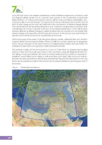
The selected models will be downscaled to a scale of 3 kilometres by dynamic downscaling
method in line with the study area shown in the map below using the Regional Climate Mo-
del. Taking into account Türkiye’s domestic and foreign policy interests and the climate and at-
mospheric events affecting our region, a wide study area up to Egypt, Italy, Russia, Iran and Uz-
bekistan has been selected and the red area representing Türkiye in the area shown in the map
below will be studied at a scale of 3 kilometres, the blue area 9 kilometres, and the green area 27
kilometres.
Map 10 Climate Projections Study Area
140