Page 237 - Çevre Şehir İklim İngilizce - Sayı 3
P. 237
Gül Aslı Aksu

               1. Material


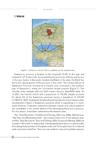
                     Figure 1. Kastamonu Central district, preferred as the research area.

               Kastamonu province is located on the longitude 33-34° to the east and
            latitude 41-42° to the north. Surrounded by the provinces of Sinop and Çorum
            in the east, Çankırı in the south, Karabük and Bartın in the west, the Black Sea
            forms the natural border of the province in the north. The Central District of
            Kastamonu Province, selected as a research area, is located in the southern
            part  of  Kastamonu,  where  the  continental  climate  prevails  (Figure  1).  The
            altitude varies between 620 and 2610 meters (Source: AsterDEM data). As
            of 2021, the Central district with a  population of 152,541 people accounts
            for  about  2/5  of  the  Kastamonu  province  having  a  population  of  375,592
            (TURKSTAT, 2021). Kuzeykent Neighborhood displays the most intense urban
            development impact in Kastamonu province which is expanding in a north-
            south direction. A dynamic interaction between natural and cultural patterns
            are remarkable in the central district of the developing Kastamonu province.
            For this reason, it has been preferred as the research area.
               The ”Küre Mountains“ (Yurdakul and Özhatay, 2005; Lise, 2006), defined as an
            ”Key Flora and Biodiversity Area“, are located in the north of the research area,
            and the ”Ilgaz Mountains” (Avcı and Özhatay, 2005; Erciyas and Menteş, 2006) are
            located in the south. In these areas, 2 endangered plant taxa on a global scale,
            65 endangered plant taxa on European scale and 18 rare plant taxa on a national
            scale have been identified. There are also endemic ones among these species.


            222 Journal of Environment, Urbanization and Climate

