
Page 143 - Çevre Şehir İklim İngilizce - Sayı 2
P. 143
Elçin Sarı - Sevim Pelin Öztürk - İmdat As
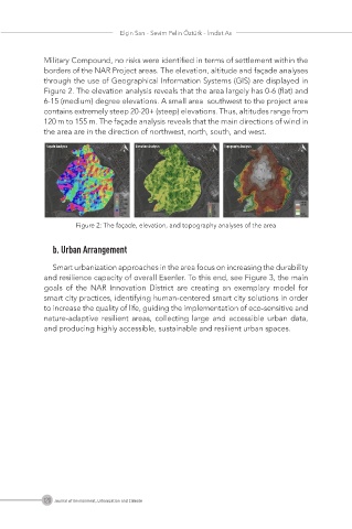
Military Compound, no risks were identified in terms of settlement within the
borders of the NAR Project areas. The elevation, altitude and façade analyses
through the use of Geographical Information Systems (GIS) are displayed in
Figure 2. The elevation analysis reveals that the area largely has 0-6 (flat) and
6-15 (medium) degree elevations. A small area southwest to the project area
contains extremely steep 20-20+ (steep) elevations. Thus, altitudes range from
120 m to 155 m. The façade analysis reveals that the main directions of wind in
the area are in the direction of northwest, north, south, and west.
Façade Analysis Elevation Analysis Topography Analysis
Figure 2: The façade, elevation, and topography analyses of the area
b. Urban Arrangement
Smart urbanization approaches in the area focus on increasing the durability
and resilience capacity of overall Esenler. To this end, see Figure 3, the main
goals of the NAR Innovation District are creating an exemplary model for
smart city practices, identifying human-centered smart city solutions in order
to increase the quality of life, guiding the implementation of eco-sensitive and
nature-adaptive resilient areas, collecting large and accessible urban data,
and producing highly accessible, sustainable and resilient urban spaces.
129 Journal of Environment, Urbanization and Climate