
Page 146 - Çevre Şehir İklim İngilizce - Sayı 2
P. 146
The Resilient City Of The Future:
Esenler Nar Innovation District
The grid system is deformed according to the land topography, transportation
routes and green areas based on a calculated design approach. The purpose of
the grid deformation is to provide settlements suitable for the land elevation,
create a green zone that links the green areas around the project area, and
provide pedestrians with easy access to transportation routes. In the Esenler
District North Topkule-Baştabya Reserve Area 1/5000 scale Master plan, 95.444
m2 to the northwest and southeast is reserved for tree nursery and green areas. As
a result of the study, places unsuitable in terms of land elevation are considered
as green areas. The green area per person in Esenler District is currently 1
m2/person. In the NAR Innovation District, it increases to 22m2/person. The
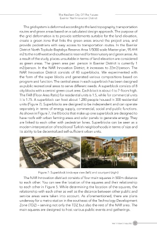
NAR Innovation District consists of 40 superblocks. We experimented with
the form of the super blocks and generated various compositions based on
program and function. The central areas in each superblock has been designed
as public recreational areas to serve different needs. A superblock consists of 8
city blocks with a central green court area. Each block is about 4 to 7-floors high.
The FAR (Floor Area Ratio) for residential units is 1.5, while for commercial units
it is 1.75. A superblock can host about 1.200 people housed in 300 residential
units (Figure 7). Superblocks are designed to be independent and can operate
separately in terms of energy supply, commercial, social and public functions.
As shown in Figure 7, the 8 blocks that make up one superblock are designed to
have roofs with urban farming areas and solar panels to generate energy. They
are linked to each other with pedestrian lanes. Superblocks can be seen as a
modern interpretation of traditional Turkish neighborhoods in terms of size and
its ability to be decentralized self-sufficient urban units.
Figure 7: Superblock birds-eye view (left) and courtyard (right)
The NAR Innovation distriact consists of four main squares in 500m distance
to each other. You can see the location of the squares and their relationship
to each other in Figure 5. While determining the location of the squares, the
relationship with each other as well as the distance between other public and
service areas were taken into account. As aforementioned, there are plans
underway for a metro station in the southeast of the Technology Development
Zone (TDZ) – serving not only the TDZ but also the rest of the NAR area. The
main squares are designed to host various public events and gatherings.
Year 1 / Issue 2 / July 2022 132