
Page 197 - Çevre Şehir ve İklim Dergisi İngilizce - Özel Sayı
P. 197
Bilgi Sarihan - Ramazan Acar Çakır
Aydın Uzun
With the model approach, it is aimed to present the wind erosion situation at
the national scale and, when necessary, at different watershed sizes, as part of the
outcomes of the study. At the end of 2018, after updating all the parameters of
the model, the map showing the amount of sediment transported due to wind
erosion and the areas with wind erosion potential at the national scale revealed
that, in the initial findings, severe and very severe wind erosion sensitivity was
calculated for an area of 1.2 million hectares. Spatially, the Kızılırmak, Konya,
and Dicle-Fırat basins stand out as the basins with the highest sensitivity. At the
local scale, Konya-Karapınar, Iğdır-Aralık, and some coastal dunes exhibit high
sensitivity. The model study has revealed that wind erosion sensitivity is very severe
in arid and semi-arid areas with vast plains, lacking vegetation cover, exposed to
strong winds, with a long and significant soil moisture deficit, and areas that have
undergone land degradation and are on the verge of desertification, as well as
in dunes. At the same time, the model plays an important role in identifying the
areas that serve as the material source for sand-dust storms.
2.3. Marginal Areas
Another significant issue in arid and semi-arid areas is the threat of
salinization-alkalization (barrenness), which is also referred to as marginal land.
According to the World Soil Map data, it is reported that 954 million hectares
of land worldwide have experienced a significant decrease in agricultural
productivity due to salinity issues. Salinity occurs, especially in agricultural
areas, in dry and semi-arid regions where improper irrigation methods and
weak drainage are present (Ekmekçi, 2005).
According to the salinity-alkalinity criteria of the Turkey’s Developed Soil Map
Studies (1966-1971), there is salinity (salinization-alkalization) in 1,518,722 hectares
of land in the country. According to the Provincial Land Resources Reports of
the General Directorate of Village Services, the total area in the country affected
by drainage and salinity problems is 2,569,297 hectares (Sönmez, 2003). The salt
that accumulates in the soil alter its physical and chemical structure, hindering
the development of plants in the region (Güngör, 1993).
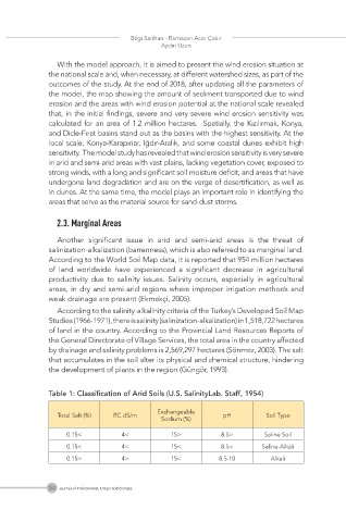
Table 1: Classification of Arid Soils (U.S. SalinityLab. Staff, 1954)
Exchangeable
Total Salt (%) EC dS/m pH Soil Type
Sodium (%)
0.15< 4< 15> 8.5> Saline Soil
0.15< 4< 15< 8.5< Saline-Alkali
0.15> 4> 15< 8.5-10 Alkali
184 Journal of Environment, Urban and Climate