
Page 196 - Çevre Şehir ve İklim Dergisi İngilizce - Özel Sayı
P. 196
Use of Climate-Resilient Plants in Arid and Semi-Arid Lands
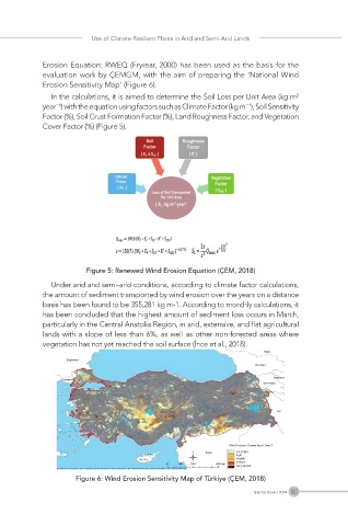
Erosion Equation: RWEQ (Fryrear, 2000) has been used as the basis for the
evaluation work by ÇEMGM, with the aim of preparing the ‘National Wind
Erosion Sensitivity Map’ (Figure 6).
In the calculations, it is aimed to determine the Soil Loss per Unit Area (kg m²
year⁻¹) with the equation using factors such as Climate Factor (kg m⁻¹), Soil Sensitivity
Factor (%), Soil Crust Formation Factor (%), Land Roughness Factor, and Vegetation
Cover Factor (%) (Figure 5).
Figure 5: Renewed Wind Erosion Equation (ÇEM, 2018)
Under arid and semi-arid conditions, according to climate factor calculations,
the amount of sediment transported by wind erosion over the years on a distance
basis has been found to be 355,281 kg m-1. According to monthly calculations, it
has been concluded that the highest amount of sediment loss occurs in March,
particularly in the Central Anatolia Region, in arid, extensive, and flat agricultural
lands with a slope of less than 6%, as well as other non-forested areas where
vegetation has not yet reached the soil surface (İnce et al., 2018).
Figure 6: Wind Erosion Sensitivity Map of Türkiye (ÇEM, 2018)
183
Special Issue / 2024