
Page 195 - Çevre Şehir ve İklim Dergisi İngilizce - Özel Sayı
P. 195
Bilgi Sarihan - Ramazan Acar Çakır
Aydın Uzun
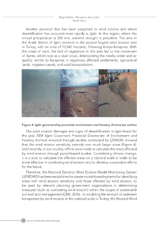
Another province that has been subjected to wind erosion and where
desertification has occurred most rapidly is Iğdır. In this region, where the
annual precipitation is 250 mm, extreme drought is prevalent. The area in
the Aralık district of Iğdır province is the second largest wind erosion area
in Turkey, with an area of 13,542 hectares, following Konya-Karapınar. With
the onset of wind, the lack of vegetation in this area led to the movement
of dunes, which rose as a dust cloud, deteriorating the nearby water and air
quality; similar to Karapınar, it negatively affected settlements, agricultural
lands, irrigation canals, and road transportation.
Figure 4: Iğdır governorship provincial environment and forestry directorate archive
The wind erosion damages and signs of desertification in Iğdır-Aralık for
the year 2004 (Iğdır Governor’s Provincial Directorate of Environment and
Forestry Archive) revealed through studies conducted by ÇEMGM, showed
that the wind erosion sensitivity extends over much larger areas (Figure 6).
Until recently, in our country, efforts were made to calculate the areas affected
by wind erosion through parcel-based studies. Considering climate change,
it is crucial to calculate the affected areas on a national scale in order to be
more effective in combating wind erosion and to develop sustainable efforts
for the future.
Therefore, the National Dynamic Wind Erosion Model Monitoring System
(UDREMİS) has been established to create model-based systems for identifying
areas with wind erosion sensitivity and those affected by wind erosion, to
be used by relevant planning government organizations in determining
measures (such as combating wind erosion) within the scope of sustainable
soil and land management (ÇEM, 2016). In modeling the amount of sediment
transported by wind erosion at the national scale in Turkey, the Revised Wind
182 Journal of Environment, Urban and Climate