
Page 194 - Çevre Şehir ve İklim Dergisi İngilizce - Özel Sayı
P. 194
Use of Climate-Resilient Plants in Arid and Semi-Arid Lands
rocks weather and break down into sizes that can be carried by the wind. In the region,
the formation of dunes and dune topography, which are part of the desertification
processes, is undoubtedly primarily influenced by wind deflation (Erinç, 1963). In areas
where the frequency, speed, and intensity of the wind are capable of moving materials
and depositing them elsewhere, factors such as the loose structure of the soils, the
presence of lime, salt, and gypsum, and the sandy texture reduce the resistance of the
soil to wind erosion. Natural steppe has spread in the region, which is under the threat
of drought with a potential evapotranspiration of 1,500 mm and precipitation varying
between 200-300 mm annually. The sparse distribution of steppe, combined with
improper land use and overgrazing, leads to the destruction of vegetation, which is the
most effective sustainable factor (vegetation) in preventing wind erosion. The drying
up of wetlands has caused the soil surface to dry out and turn into dust. All these
factors, combined with human-induced land degradation, overgrazing, and improper
land use, have led to an increase in sand and dust storms, commonly seen in desert
regions, in the Karapınar Plain. These storms have threatened agricultural lands, road
transportation, air and water quality, and settlements, forcing people to migrate
(Özdemir, 2023). In the plain, the dominant wind directions are winds originating from
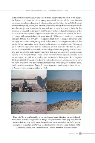
the north and south. The dominant southwest winds, which carry soil materials (sand,
dust) towards the northeast (Figure 3), have transported sand dunes as far as the front
of Karapınar during this period (Erinç, 1963).
Figure 3: The area affected by wind erosion and desertification, human-induced
destruction of natural vegetation in Konya-Karapinar in the 1960s (top left), the for-
mation of dunes (top right), negatively affected settlements (bottom left), and an
example of an aeolian landform, a sand relief, formed in a hill area (bottom right)
(Konya Soil, Water, and Desertification Combat Research Station Archive)
181
Special Issue / 2024