
Page 177 - Çevre Şehir İklim İngilizce - Sayı 4
P. 177
Fred Barış Ernst - İbrahim Yenigün
360 VR, such as CityEngine, which makes it possible to compare “before
design” and “after design” by viewing new designs in a VR environment.
Among these, CityEngine is a software that applies the rule-based modeling
concept and has proven its success in creating 3D models (Kelly, 2021). The VR
scenes used in the workshop on “Alternative Futures for Şanlıurfa - Türkiye”
mentioned above were prepared using CityEngine (Ernst et al., 2020).
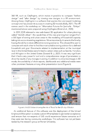
In 2019, ESRI released a new web-based 3D application for urban planning
called “ArcGIS Urban”, the capabilities of this new planning tool ranged from
a GIS layer of zoning and urban areas to the modeling of household capacity
taking into account existing regulations. More importantly, it came to the fore by
having the ability to store different re-zoning scenarios. This allowed the user to
compare with each other to find the most suitable zoning solution for a defined
household unit goal. Documents related to implementation at the municipal
level in the United States were limited to certain cities such as Seattle, Honolulu
and Arlington in the United States (Soward & Li, 2021). It was very significant
that it had a very powerful tool and a comprehensive range of parameters to
show the results of any changes in zoning. In addition to attractive images in 3D
mode, the availability of short reports, dashboards and additional media were
other prominent features among other presentation tools (Figure 6).
Figure 6. ArcGIS Urban showing the risk of flood for the US city of Boston
An additional feature of this software was the deployment of the Unreal
Engine and the option to create custom VR templates to get better acceptance
and ensure that non-experts of GIS could experience future scenarios as if
they were real during community workshops. This software has not yet been
tested by the research group at Harran University.
166 The Journal of Environment, Urban and Climate