
Page 174 - Çevre Şehir İklim İngilizce - Sayı 4
P. 174
Resilient Cities From Geodesign Perspective:
The Case of Şanlıurfa Province
are prioritized while selecting and planning the existing development areas.
Thus, undesirable activities such as the construction of high-rise buildings on
alluviums will be avoided in the future.
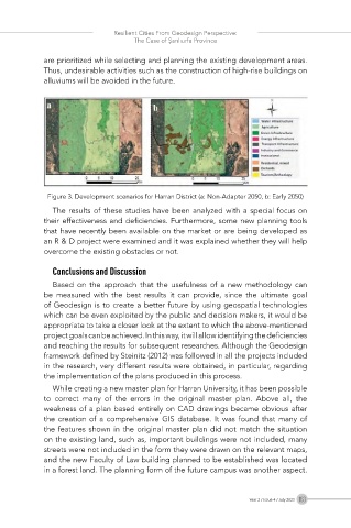
Figure 3. Development scenarios for Harran District (a: Non-Adapter 2050, b: Early 2050)
The results of these studies have been analyzed with a special focus on
their effectiveness and deficiencies. Furthermore, some new planning tools
that have recently been available on the market or are being developed as
an R & D project were examined and it was explained whether they will help
overcome the existing obstacles or not.
Conclusions and Discussion
Based on the approach that the usefulness of a new methodology can
be measured with the best results it can provide, since the ultimate goal
of Geodesign is to create a better future by using geospatial technologies
which can be even exploited by the public and decision makers, it would be
appropriate to take a closer look at the extent to which the above-mentioned
project goals can be achieved. In this way, it will allow identifying the deficiencies
and reaching the results for subsequent researches. Although the Geodesign
framework defined by Steinitz (2012) was followed in all the projects included
in the research, very different results were obtained, in particular, regarding
the implementation of the plans produced in this process.
While creating a new master plan for Harran University, it has been possible
to correct many of the errors in the original master plan. Above all, the
weakness of a plan based entirely on CAD drawings became obvious after
the creation of a comprehensive GIS database. It was found that many of
the features shown in the original master plan did not match the situation
on the existing land, such as, important buildings were not included, many
streets were not included in the form they were drawn on the relevant maps,
and the new Faculty of Law building planned to be established was located
in a forest land. The planning form of the future campus was another aspect.
Year 2 / Issue 4 / July 2023 163