
Page 171 - Çevre Şehir ve İklim Dergisi İngilizce - Özel Sayı
P. 171
Engin Yildiz - İsmail Bulut
These data reveals the severity of the avalanche hazard in the region and
the need for emergency response as well as emphasizing the importance of
hazard mapping and risk analysis.
2.1. Study Area
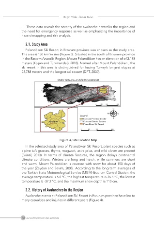
Palandöken Ski Resort in Erzurum province was chosen as the study area.
The area is 150 km² in size (Figure 3). Situated in the south of Erzurum province
in the Eastern Anatolia Region, Mount Palandöken has an elevation of of 3.188
meters (Koşan and Türkmendağ, 2018). Named after Mount Palandöken , the
ski resort in this area is distinguished for having Turkey’s longest slopes at
25,788 meters and the longest ski season (DPT, 2000).
Figure 3, Site Location Map
In the selected study area of Palandöken Ski Resort, plant species such as
alpine tuft grasses, thyme, mugwort, astragalus, and wild clover are present
(Günal, 2013). In terms of climate features, the region dislays continental
climate conditions. Winters are long and harsh, while summers are short
and warm. Mount Palandöken is covered with snow for about 150 days of
the year (Zeydan and Sevim, 2008). According to the long-term averages of
the Turkish State Meteorological Service (MGM) Erzurum Central Station, the
average temperature is 5.8 °C, the highest temperature is 36.5 °C, the lowest
temperature is -37.2 °C, and the maximum snow depth is 110 cm.
2.2. History of Avalanches in the Region
Avalanche events at Palandöken Ski Resort in Erzurum province have led to
many casualties and injuries in different years (Figure 4).
158 Journal of Environment, Urban and Climate