
Page 136 - Çevre Şehir ve İklim Dergisi İngilizce - Özel Sayı
P. 136
National Scale Land Cover Classification and Monitoring System
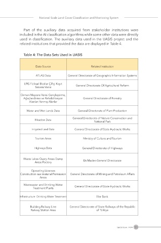
Part of the auxiliary data acquired from stakeholder institutions were
included in the AI classification algorithms while some other data were directly
used in classification. The auxiliary data used in the UASIS project and the
related institutions that provided the data are displayed in Table 4.
Table 4: The Data Sets Used in UASIS
Data Source Related Institution
ATLAS Data General Directorate of Geographic Information Systems
LPIS Fiziksel Bloklar Çiftçi Kayıt General Directorate Of Agricultural Reform
Sistemi Verisi
Orman Meşcere Verisi Gençleştirme,
Ağaçlandırma ve Rehabilitasyon General Directorate of Forestry
Alanları Yanmış Alanlar
Water and Wet Lands Data General Directorate of Plant Production
General Directorate of Nature Conservation and
Meadow Data
National Park
Irrigated Land Data General Directorate of State Hydraulic Works
Tourism Areas Ministry of Culture and Tourism
Highways Data General Directorate of Highways
Waste Lakes Quary Areas Dump Eti Maden General Directorate
Areas Factory
Operating Licenses
Construction raw material Permission General Directorate of Mining and Petroleum Affairs
Areas
Wastewater and Drinking Water General Directorate of State Hydraulic Works
Treatment Plants
Infrastructure Drinking Water Treatment İller Bank
Building Railway Line General Directorate of State Railways of the Republic
Railway Station Area of Türkiye
123
Special Issue / 2024