
Page 135 - Çevre Şehir ve İklim Dergisi İngilizce - Özel Sayı
P. 135
Murat Arslan - Reyhan Çakir - İsra Akyazi
Nida Kumbasar - Ahmet Doğan - Emre Yavuz
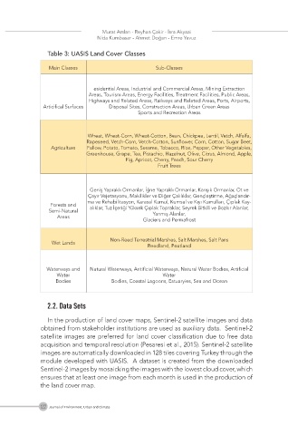
Table 3: UASIS Land Cover Classes
Main Classes Sub-Classes
esidential Areas, Industrial and Commercial Areas, Mining Extraction
Areas, Tourism Areas, Energy Facilities, Treatment Facilities, Public Areas,
Highways and Related Areas, Railways and Related Areas, Ports, Airports,
Articifical Surfaces Disposal Sites, Construction Areas, Urban Green Areas
Sports and Recreation Areas
Wheat, Wheat-Corn, Wheat-Cotton, Bean, Chickpea, Lentil, Vetch, Alfalfa,
Rapeseed, Vetch-Corn, Vetch-Cotton, Sunflower, Corn, Cotton, Sugar Beet,
Agriculture Fallow, Potato, Tomato, Sesame, Tobacco, Rice, Pepper, Other Vegetables,
Greenhouse, Grape, Tea, Pistachio, Hazelnut, Olive, Citrus, Almond, Apple,
Fig, Apricot, Cherry, Peach, Sour Cherry
Fruit Trees
Geniş Yapraklı Ormanlar, İğne Yapraklı Ormanlar, Karışık Ormanlar, Ot ve
Çayır Vejetasyonu, Makilikler ve Diğer Çalılıklar, Gençleştirme, Ağaçlandır-
ma ve Rehabilitasyon, Karasal Kumul, Kumsal ve Kıyı Kumulları, Çıplak Kay-
Forests and
Semi-Natural alıklar, Tuz İçeriği Yüksek Çıplak Topraklar, Seyrek Bitkili ve Bozkır Alanlar,
Yanmış Alanlar,
Areas
Glaciers and Permafrost
Non-Reed Terrestrial Marshes, Salt Marshes, Salt Pans
Wet Lands
Reedland, Peatland
Waterways and Natural Waterways, Aritificial Waterways, Natural Water Bodies, Artificial
Water Water
Bodies Bodies, Coastal Lagoons, Estuaryies, Sea and Ocean
2.2. Data Sets
In the production of land cover maps, Sentinel-2 satellite images and data
obtained from stakeholder institutions are used as auxiliary data. Sentinel-2
satellite images are preferred for land cover classification due to free data
acquisition and temporal resolution (Pesaresi et al., 2015). Sentinel-2 satellite
images are automatically downloaded in 128 tiles covering Turkey through the
module developed with UASIS. A dataset is created from the downloaded
Sentinel-2 images by mosaicking the images with the lowest cloud cover, which
ensures that at least one image from each month is used in the production of
the land cover map.
122 Journal of Environment, Urban and Climate