
Page 133 - Çevre Şehir ve İklim Dergisi İngilizce - Özel Sayı
P. 133
Murat Arslan - Reyhan Çakir - İsra Akyazi
Nida Kumbasar - Ahmet Doğan - Emre Yavuz
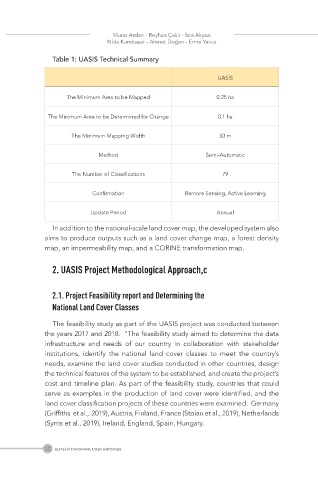
Table 1: UASIS Technical Summary
UASİS
The Minimum Area to be Mapped 0.25 ha
The Minimum Area to be Determined for Change 0.1 ha
The Minimum Mapping Width 50 m
Method Semi-Automatic
The Number of Classifications 79
Confirmation Remore Sensing, Active Learning
Update Period Annual
In addition to the national-scale land cover map, the developed system also
aims to produce outputs such as a land cover change map, a forest density
map, an impermeability map, and a CORINE transformation map.
2. UASIS Project Methodological Approach,c
2.1. Project Feasibility report and Determining the
National Land Cover Classes
The feasibility study as part of the UASIS project was conducted between
the years 2017 and 2018. “The feasibility study aimed to determine the data
infrastructure and needs of our country in collaboration with stakeholder
institutions, identify the national land cover classes to meet the country’s
needs, examine the land cover studies conducted in other countries, design
the technical features of the system to be established, and create the project’s
cost and timeline plan. As part of the feasibility study, countries that could
serve as examples in the production of land cover were identified, and the
land cover classification projects of these countries were examined. Germany
(Griffiths et al., 2019), Austria, Finland, France (Stoian et al., 2019), Netherlands
(Syrris et al., 2019), Ireland, England, Spain, Hungary.
120 Journal of Environment, Urban and Climate