
Page 41 - Çevre Şehir İklim İngilizce - Sayı 4
P. 41
Seda Kundak
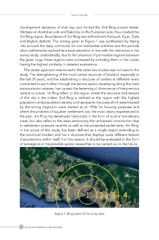
development dynamics of that day, and limited the 2nd Ring around Kartal-
Maltepe on Anatolian side and Bakırköy on the European side, thus created the
3rd Ring region. Boundaries of 3rd Ring was defined with Esenyurt, Eyüp, Tuzla
and Beykoz districts. The zoning given in Figure 1 was synthesized by taking
into account the daily commutes for non-residential activities and the periods
when settlements reached structural saturation in line with the interviews in the
survey study. Undoubtedly, due to the presence of permeable regions between
the given rings, these regions were addressed by including them in the cluster
having the highest similarity in detailed evaluations.
The center approach mentioned in the other two studies was not used in this
study. The strengthening of the multi-center structure of İstanbul, especially in
the last 20 years, and the establishing a structure of centers at different levels
connected to each other through the service sector developing along the main
transportation arteries, has caused the lessening of dominance of the previous
central structure. 1st Ring refers to the region where the structure and texture
of the city is the oldest. 2nd Ring is defined as the region with the highest
population and population density, and represents the areas which were headed
by the strong migration wave started as of 1950s for housing purposes and
where the problem of squatter settlement was the most clearly experienced in
the past. 3rd Ring has developed historically in the form of rural or low-density
areas, but also refers to the areas embracing the unlicensed construction due
to settlement pressure recently as well as the protected settlements. 4th Ring,
in the scope of this study, has been defined as a single region extending to
the provincial borders and has a structure that displays quite different texture
characteristics within itself. For this reason, it should be evaluated in the form
of subregions in the possible spatial researches to be carried out in the future.
Figure 1. Ring zones of the study area
30 The Journal of Environment, Urban and Climate