
Page 286 - Çevre Şehir İklim İngilizce - Sayı 2
P. 286
Evaluation Of Vulnerability On Turkish Coastal Provinces With Gis
• All data was converted to raster data through Feature to Raster
process.
• The resulting raster data was reclassified to be used in weighted
overlay analysis.
• Thanks to the process done with Reclassify command, all complexity
in all the raster data set is eliminated, which allowed the reduction
of the data to a certain evaluation criteria.
• After the classification process, the Weighted Overlay analysis is
implemented based on the data. During this process, each piece of
data was assigned a point depending on their level of effect. Thus,
the effect of each indicator on the analysis was observed.
• As a result of all these processes, a map was created on costal cities
with high, medium and low vulnerability.
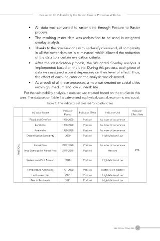
For the vulnerability analysis, a data set was created based on the studies in this
area. The data set on Table 1 is caterorized as physical, spatial, economic and social.
Table 1: The indicator set created for coastal cities
Indicator Indicator
Indicator Name Indicator Effect Indicator Unit
Period Effect Rate
Flood and Overflow 1950-2020 Positive Number of occurrence
Landslide 1950-2020 Positive Number of occurrence
Avalanche 1950-2020 Positive Number of occurrence
Desertification Sensitivity 2020 Positive High-Medium-Low
PHYSICAL Area Damaged in Forest Fires 2019-2020 Positive Number of occurrence 45%
Forest Fires
2019-2020
Hectare
Positive
Water-based Soil Erosion 2020 Positive High-Medium-Low
Temperature Anomalies 1991-2020 Positive Existent-Non-existent
Earthquake Risk 2021 Positive High-Medium-Low
Rise in Sea Levels 2021 Positive High-Medium-Low
Year 1 / Issue 2 / July 2022 272