
Page 177 - Çevre Şehir ve İklim Dergisi İngilizce - Özel Sayı
P. 177
Engin Yildiz - İsmail Bulut
Future updates will introduce new
features such as offline maps, inventory
recording, route planning, and snow
cover layers, making the application
an effective solution in combating
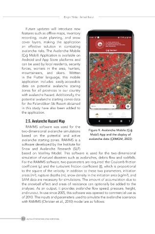
avalanche risks. The Avalanche Mobile
(Çığ Mobil) Application is available on
Android and App Store platforms and
can be used by local residents, security
forces, workers in the area, hunters,
mountaineers, and skiers. Written
in the Flutter language, this mobile
application includes easily-accessible
data on potential avalanche staring
zones for all provinces in our country
with avalanche hazard. Additionally, the
potential avalanche starting zones data
for the Palandöken Ski Resort obtained
in this study have also been added to
the application.
2.5. Avalanche Hazard Map
RAMMS software was used for the
two-dimensional avalanche simulations
based on the potential and active
avalanche starting zones. RAMMS is a
software developed by the Institute for
Snow and Avalanche Research (SLF)
based on Voellmy Model. This software is used for the two-dimensional
simulation of natural disasters such as avalanches, debris flow and rockfalls.
For the RAMMS software, two parameters are required: the Coulomb friction
coefficient (μ) and the turbulent friction coefficient (ξ), which is proportional
to the square of the velocity. In addition to these two parameters, initiation
areas (m²), rupture depths (m), snow density in the initiation area (kg/m³), and
SAM data are necessary for simulations. The amount of accumulation due to
the snowball effect and areas of resistance can optionally be added to the
analyses. As an output, it provides avalanche flow speed, pressure, height,
and runout. In use since 2005, this software was opened to commercial use as
of 2010. The inputs and parameters used to simulate the avalanche scenarios
with RAMMS (Christen et al., 2010) model are as follows:
164 Journal of Environment, Urban and Climate