
Page 156 - Çevre Şehir ve İklim Dergisi İngilizce - Özel Sayı
P. 156
Determination of Erosion Statistics by Land Use Type at National Scale With the
Dynamic Erosion Model and Monitoring System (Demms)
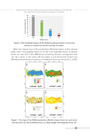
Figure 2. The individual impacts of the RUSLE model parameters on the total
amount of eroded soil and the severity of erosion.
When the impact level of the parameters affecting erosion at the national
scale, even if topography seems to be the most impactful factor, its impact
levels can vary due to the differences caused by climate, ecology and land
use. As a result, in the areas with low slope, it was found that erosion was
directly associated with the factors of rainfall and land cover (Erpul et al., 2018).
Figure 1. The maps of the RUSLE parameters; Rainfall erosion factor (a), Land cover
and use factor (b), Soil erodibility factor (c), Slope length and steepness factor (d).
143
Special Issue / 2024