
Page 157 - Çevre Şehir ve İklim Dergisi İngilizce - Özel Sayı
P. 157
İskender Demirtaş - Günay Erpu
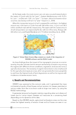
At the basin scale, the most erosion per unit area occurred respectively in
the basins of Çoruh with 26 t ha⁻¹year⁻¹, Eastern Mediterranean with 15,23 t
ha⁻¹year⁻¹, and Asi with 13,81 t ha⁻¹year⁻¹. The basin, where the lowest erosion
occurred, was Sakarya with 4,2 t ha⁻¹year⁻¹ (Erpul et al., 2018).
When the transported amount of soil is assessed for each basin, the highest
amount was in the basins of Dicle-Fırat with 160 million tons, in Çoruh with 45.5
million and Kızılırmak with 45.5 respectively. The basins with the lowest amount
of soil transportation are respectively Burdur with 3.6 million tons, Akarçay with
4.8 million tons, and Küçük Menderes with 7.5 million tons (Erpul et al., 2018).
Figure 2. Türkiye Water Erosion Map created as a result of the integration of
DEMMS software and the RUSLE model
As these findings show the impact of the topographic structure on erosion
severity, they also indicate that the amount and severity of erosion vary among
the regions with different climate conditions, vegetation, land use and various
agricultural practices. The necessity of urgent interventions is also emphasized
for the agricultural and pasture areas, which are generally the most susceptible
to and have the highest levels of land degradation as well as the regions with
moderate and severe erosion levels.
4. Results and Recommendations
DEMMS was operated at the national scale, and it generated the maps
and statistical results of land losses and soil erosion risk classes, predicted at
various scales, from the micro-basin scale to large river basins, by using the
RUSLE methodology.
It generates temporal and spatial statistics regarding when and where soil
losses due to human impact threaten soil resources at a concerning level
depending on the dynamics of the data.
Based on the DEMMS results, agricultural and pasture areas are the ones
where the highest severity of erosion threat and soil losses are seen in our
144 Journal of Environment, Urban and Climate