
Page 154 - Çevre Şehir ve İklim Dergisi İngilizce - Özel Sayı
P. 154
Determination of Erosion Statistics by Land Use Type at National Scale With the
Dynamic Erosion Model and Monitoring System (Demms)
As a result of comprehensive calculations for rainfall intensities and
energy flows, the impacts of climate severity were determined for the soil
erosion which has occurred in our country. For the soil data, the K factor map
was created by using all data obtained at the national scale. Also, for the
vegetation assessment, new data sets were created by using CORINE2018
data and forest stand maps, and the C factor values, which were determined
by Panagos et al., (2015), were assigned for the most suitable land cover and
use classes in our country.
In this study, the RUSLE technology was methodologically reinforced with RS
and GIS in order to use the model parameters more effectively at the national scale.
For national purposes, DEMMS was operated at the micro-basin and provincial
scale, in accordance with potential further scaling. Additionally, the statistical soil
erosion data from 25 river basins in Türkiye, detailed maps for severity assessment
and Türkiye’s Water Erosion Map (Figure 4) were created. With DEMMS, a Water
Erosion Atlas was prepared and published (Erpul et al., 2018).
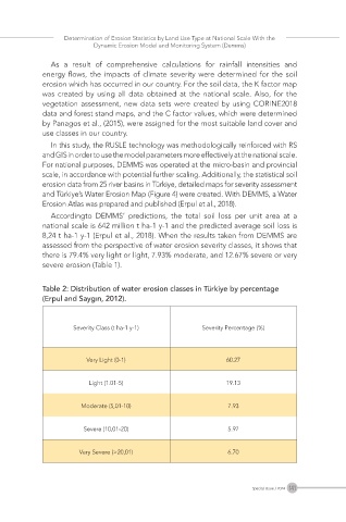
Accordingto DEMMS’ predictions, the total soil loss per unit area at a
national scale is 642 million t ha-1 y-1 and the predicted average soil loss is
8,24 t ha-1 y-1 (Erpul et al., 2018). When the results taken from DEMMS are
assessed from the perspective of water erosion severity classes, it shows that
there is 79.4% very light or light, 7.93% moderate, and 12.67% severe or very
severe erosion (Table 1).
Table 2: Distribution of water erosion classes in Türkiye by percentage
(Erpul and Saygın, 2012).
Severity Class (t ha-1 y-1) Severity Percentage (%)
Very Light (0-1) 60.27
Light (1.01-5) 19.13
Moderate (5,01-10) 7.93
Severe (10,01-20) 5.97
Very Severe (>20,01) 6.70
141
Special Issue / 2024