
Page 250 - Çevre Şehir İklim İngilizce - Sayı 2
P. 250
Where Do Strong Winds And Storms Stand
In The Context Of Climate Change?
warnings. It is seen that “A Look at 2019 in terms of Disaster Administration
and Nature-based Phenomenon Statistics” report by AFAD includes
earthquakes, landslides/rock falls, floods/overflows, and avalanches under
the title, 2019 natural disasters statistics, while it does not include storms.
However, in the same report, the graph on AYDES (Disaster Administration
and Decision Support System) records showing the distribution of disaster
types displays 110 records of storms/whirlwinds and 83 cases of intervention
to these disasters (AFAD, 2020: 61). Thus, regarding this data, it wouldn’t be
wrong to say that there is not enough emphasis on disasters caused by strong
winds.
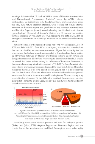
When the data on the recorded winds with 10.8 m/sec between Jan 1st
2020 and Feb 28th 2021 from MGM is analyzed, it is seen that speed values
that can be classified as storms were observed (Figure 1a). In the light of this
information, the highest speed was recorded in Afyonkarahisar-Local station
as 48.9 m/sec, followed by Hakkari and Manisa stations as 33.4 m/sec and
Zonguldak station as 33.4 m/sec. According to Beaufort wind scale, it should
be noted that these values belong to definition of hurricane. Moreover, in
the same observatory, winds with a speed of 17.2-20.7 m/sec (Beaufort wind
scale: storm) and over were recorded around the country 378 times. This value
makes up the %7.6 of all wind speed records (figure 1b). It is also observed
that the distribution of stations where wind values that should be categorized
as storm and above is not concentrated in a single area. To the contrary, they
are distributed all around Türkiye. When the results of these records spanning
a period of 13 months are analyzed, it is obvious that Türkiye hosts winds with
speeds that can cause disasters.
Figure 1: a) The wind speed records of 10.8 m/sec and above between
Jan 1st 2020 and Feb 28th 2021, acquired from MGM as part of the BAP project. 1:b)
According to these records, the wind type distribution (Wind speed classification
was made by Meriç Aziz Berge based on Beaufort scale).
According to the storm disaster potential risk map for Türkiye in general
(Türkeş and Şahin, 2018), Aegean Region and Marmara Region and the
coastal line of the Mediterranean and Black Sea regions seem to be highly
Year 1 / Issue 2 / July 2022 236