
Page 122 - Çevre Şehir ve İklim Dergisi İngilizce - Özel Sayı
P. 122
Development of Desertification Maps and Vulnerability Model, Türkiye
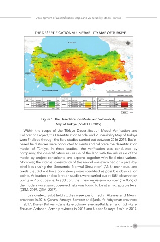
Table 2: Desertification Index Values and Their Definition (ÇEM 2017).
THE DESERTIFICATION VULNERABILITY MAP OF TÜRKİYE
Vulnerability Class Class Index Values Definition
1 1.0-1.27 Low
Low 2 1.28-1.34 Moderate
3 1.35-1.40 High
4 1.41-1.45 Low
Moderate 5 1.46-1.48 Moderate
6 1.49-1.54 High
7 1.55-1.60 Low
High 8 1.61-1.67 Moderate
Figure 1. The Desertification Model and Vulnerability
9 1.68-2.00 High Map of Türkiye (NSAPCD, 2019)
Within the scope of the Türkiye Desertification Model Verification and
Calibration Project, the Desertification Model and Vulnerability Map of Türkiye
As a result of these analyses and studies, the Desertification Model and were finalised through the field studies carried out between 2016-2019. Basin-
Vulnerability Map of Türkiye were created. Among the criteria and indicators based field studies were conducted to verify and calibrate the desertification
identified on the map, climate, soil, topography and land cover data were used model of Türkiye. In these studies, the verification was conducted by
and in this respect, the map has a biogeophysical feature. It was planned that comparing the desertification risk value of the land with the risk value of the
the water, socioeconomic and management criteria and indicators identified model by project consultants and experts together with field observations.
within the scope of this study and affecting desertification would be reflected Moreover, the internal consistency of the model was examined on a pixel-by-
later in the model within the framework of the AHP designed (ÇEM, 2017). pixel basis using the ‘Sequential Normal Simulation’ (ANB) technique, and
According to the map, the highly vulnerable areas in Türkiye are Konya pixels that did not have consistency were identified as possible observation
Basin and Ankara and Eskişehir regions in Central Anatolia Region; Şanlıurfa, points. Validation and calibration studies were carried out at 1584 observation
Mardin and Diyarbakır regions close to the Syrian border in Southeastern points in 9 pilot basins. In addition, the linear regression number (r = 0.79) of
Anatolia Region, as well as a small area in Malatya region, Iğdır and Aralık and the model risks against observed risks was found to be at an acceptable level
Doğubayazıt regions, and these areas are considered as priority areas in (ÇEM, 2019, ÇEM, 2017).
combating desertification. This model and map show that 18% of the lands of In this context, pilot field studies were performed in Aksaray and Mersin
Türkiye are in the weak, 50.9% moderate and 22.5% high desertification provinces in 2016, Çorum- Amasya-Samsun and Şanlıurfa-Adıyaman provinces
vulnerability class (Figure 1) (ÇEM, 2019).
in 2017, Bursa- Balıkesir-Çanakkale-Edirne-Tekirdağ-Kırklareli and Iğdır-Kars-
Erzurum-Ardahan- Artvin provinces in 2018 and Upper Sakarya Basin in 2019.
109
Special Issue / 2024