
Page 121 - Çevre Şehir ve İklim Dergisi İngilizce - Özel Sayı
P. 121
Zehra Kavakli Karataş
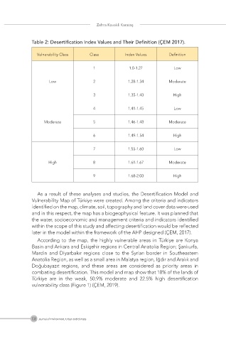
Table 2: Desertification Index Values and Their Definition (ÇEM 2017).
Vulnerability Class Class Index Values Definition
1 1.0-1.27 Low
Low 2 1.28-1.34 Moderate
3 1.35-1.40 High
4 1.41-1.45 Low
Moderate 5 1.46-1.48 Moderate
6 1.49-1.54 High
7 1.55-1.60 Low
High 8 1.61-1.67 Moderate
9 1.68-2.00 High
As a result of these analyses and studies, the Desertification Model and
Vulnerability Map of Türkiye were created. Among the criteria and indicators
identified on the map, climate, soil, topography and land cover data were used
and in this respect, the map has a biogeophysical feature. It was planned that
the water, socioeconomic and management criteria and indicators identified
within the scope of this study and affecting desertification would be reflected
later in the model within the framework of the AHP designed (ÇEM, 2017).
According to the map, the highly vulnerable areas in Türkiye are Konya
Basin and Ankara and Eskişehir regions in Central Anatolia Region; Şanlıurfa,
Mardin and Diyarbakır regions close to the Syrian border in Southeastern
Anatolia Region, as well as a small area in Malatya region, Iğdır and Aralık and
Doğubayazıt regions, and these areas are considered as priority areas in
combating desertification. This model and map show that 18% of the lands of
Türkiye are in the weak, 50.9% moderate and 22.5% high desertification
vulnerability class (Figure 1) (ÇEM, 2019).
108 Journal of Environment, Urban and Climate