
Page 120 - Çevre Şehir ve İklim Dergisi İngilizce - Özel Sayı
P. 120
Development of Desertification Maps and Vulnerability Model, Türkiye
the inconsistency is statistically acceptable; if not, the subjective judgement
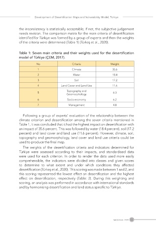
needs revision. The comparison matrix for the main criteria of desertification
identified for Türkiye was formed by a group of experts and then the weights
of the criteria were determined (Table 1) (Türkeş et al., 2020).
Table 1: Seven main criteria and their weights used for the desertification
model of Türkiye (ÇEM, 2017).
No Criteria Weight
1 Climate 35.6
2 Water 18.4
3 Soil 17.2
4 Land Cover and Land Use 11.6
Topography and
5 6.3
Geomorphology
6 Socio-economy 6.2
7 Management 4.8
Following a group of experts’ evaluation of the relationship between the
climate criterion and desertification among the seven criteria mentioned in
Table 1, it was concluded that it had the highest impact on desertification with
an impact of 35.6 percent. This was followed by water (18.4 percent), soil (17.2
percent) and land cover and land use (11.6 percent). However, climate, soil,
topography and geomorphology, land cover and land use criteria could be
used to produce the final map.
The weights of the desertification criteria and indicators determined for
Türkiye were assessed according to their impacts, and standardised data
were used for each criterion. In order to render the data used more easily
comprehensible, the indicators were divided into classes and given scores
to determine to what extent and under which conditions they affected
desertification (Türkeş et al., 2020). This scoring was made between 1 and 2, and
this scoring represented the lowest effect on desertification and the highest
effect on desertification, respectively (Table: 2). During this weighting and
scoring, an analysis was performed in accordance with international standards
and by harmonising desertification and land status specific to Türkiye.
107
Special Issue / 2024