
Page 317 - 7. State Of Environment Report Of Türkiye
P. 317
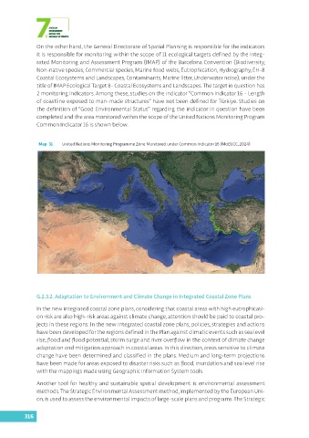
On the other hand, the General Directorate of Spatial Planning is responsible for the indicators
               it is responsible for monitoring within the scope of 11 ecological targets defined by the Integ-
               rated Monitoring and Assessment Program (IMAP) of the Barcelona Convention (Biodiversity,
               Non-native species, Commercial species, Marine food webs, Eutrophication, Hydrography, EH-8
               Coastal Ecosystems and Landscapes, Contaminants, Marine litter, Underwater noise), under the
               title of IMAP Ecological Target 8- Coastal Ecosystems and Landscapes. The target in question has
               2 monitoring indicators. Among these, studies on the indicator “Common Indicator 16 - Length
               of coastline exposed to man-made structures” have not been defined for Türkiye. Studies on
               the definition of “Good Environmental Status” regarding the indicator in question have been
               completed and the area monitored within the scope of the United Nations Monitoring Program
               Common Indicator 16 is shown below.


                Map  31  United Nations Monitoring Programme Zone Monitored under Common Indicator 16 (MoEUCC, 2024)


               G.2.3.2. Adaptation to Environment and Climate Change in Integrated Coastal Zone Plans

               In the new integrated coastal zone plans, considering that coastal areas with high eutrophicati-
               on risk are also high-risk areas against climate change, attention should be paid to coastal pro-
               jects in these regions. In the new integrated coastal zone plans, policies, strategies and actions
               have been developed for the regions defined in the Plan against climatic events such as sea level
               rise, flood and flood potential, storm surge and river overflow in the context of climate change
               adaptation and mitigation approach in coastal areas. In this direction, areas sensitive to climate
               change have been determined and classified in the plans. Medium and long-term projections
               have been made for areas exposed to disaster risks such as flood, inundation and sea level rise
               with the mappings made using Geographic Information System tools.

               Another tool for healthy and sustainable spatial  development is  environmental assessment
               methods. The Strategic Environmental Assessment method, implemented by the European Uni-
               on, is used to assess the environmental impacts of large-scale plans and programs. The Strategic


          316