
Page 311 - 7. State Of Environment Report Of Türkiye
P. 311
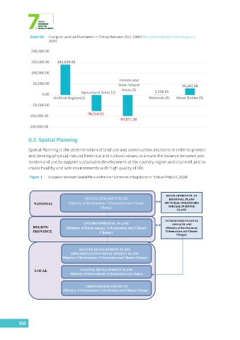
Graph 60  Change in Land Use Distribution in Türkiye Between 2012-2018 (https://corinecbs.tarimorman.gov.tr/,
                         2024)

                200,000.00

                150,000.00   141,019.95


                100,000.00
                                                            Forests and
                 50,000.00                                  Semi-Natural                   30,247.58
                                                             Areas (3)        1,118.24
                      0.00               Agricultural Areas (2)
                            Artificial Regions(1)                          Wetlands (4)     Water Bodies (5)

                 -50,000.00

               -100,000.00                  -74,514.55
                                                            -97,871.28
               -150,000.00


               G.2. Spatial Planning


               Spatial Planning is the determination of land use and construction decisions in order to protect
               and develop physical, natural, historical and cultural values, to ensure the balance between pro-
               tection and use, to support sustainable development at the country, region and city level, and to
               create healthy and safe environments with high quality of life.

                Figure  1  Gradation between Spatial Plans within the Framework of Legislation in Türkiye (MoEUCC, 2024)


                                                                                    DEVELOPMENT PLAN
                                           SPATIAL STRATEGY PLAN                     REGIONAL PLANS
                  NATIONAL         (Ministry of Environment, Urbanization and Climate   SECTORAL STRATEGIES
                                                   Change)                           SPECIAL PURPOSE
                                                                                         PLANS


                                                                                   INTEGRATED COASTAL
                                           ENVIRONMENTAL PLANS                        AREAS PLANS
                 REGION/          (Ministry of Environment, Urbanization and Climate   (Ministry of Environment,
                 PROVINCE                          Change)                         Urbanization and Climate
                                                                                         Change)


                                        MASTER DEVELOPMENT PLANS
                                    IMPLEMENTATION DEVELOPMENT PLANS
                                (Ministry of Environment, Urbanization and Climate Change)


                  LOCAL                  COASTAL DEVELOPMENT PLANS
                                    (Ministry of Environment, Urbanization and Climate


                                           URBAN DESIGN PROJECTS
                                (Ministry of Environment, Urbanization and Climate Change)


          310