
Page 296 - 7. State Of Environment Report Of Türkiye
P. 296
According to the Desertification Vulnerability Map, one of the most important studies on deser-
tification/land degradation in Türkiye, while 22.5% of Türkiye has high desertification vulnerabi-
lity, 50.9% has medium desertification vulnerability.
According to the national scale desertification criteria and indicators determined in the Türkiye
Desertification Model, while climate, water, soil, land cover and land use, topography and geo-
morphology, socio-economy and management stand out as the main factors in desertification/
land degradation in Türkiye, it has been determined that the Konya Closed Basin, the central and
southern parts of the Sakarya and Kızılırmak Basins, a significant part of the Fırat-Dicle Basin, the
part of the Thrace Region outside the Black Sea coast and the Iğdır-Aralık part of the Aras Basin
are highly susceptible to desertification.
F.5.1. Combating Desertification and Erosion
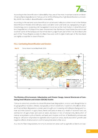
Map 19 Türkiye Water Erosion Map (MoAF, 2024)
The Ministry of Environment, Urbanization and Climate Change, General Directorate of Com-
bating Desertification and Erosion (GDCDE) Studies
Türkiye is extremely sensitive to desertification/land degradation, erosion and drought due to
its geographical location, climate, topography and soil conditions. In addition, the effects of de-
sertification/land degradation, erosion and drought are increasing with climate change and hu-
man activities. Erosion in agricultural, forest and pasture areas as a result of incorrect land use,
destruction of agricultural and pasture lands, decrease or loss of productivity, destruction of
natural ecosystems such as forests, wetlands and steppes and loss of biodiversity, misuse and
irregular utilization of productive agricultural and pasture areas, rapid population growth and
negative effects of urbanization are the basic phenomena that occur.
As a result of land degradation, not only in production areas such as agricultural lands and pas-
295