
Page 301 - 7. State Of Environment Report Of Türkiye
P. 301
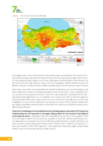
Map  20  Türkiye Desertification Vulnerability Map


               According to the ‘Türkiye Desertification Vulnerability Map’, approximately 22.5 percent of Tür-
               kiye’s lands are highly susceptible to desertification. While Konya-Karapınar, Iğdır-Aralık and Ur-
               fa-Ceylanpınar are seen as regions with a very high degree of vulnerability to desertification, the
               Salt Lake basin, the Ereğli-Karaman region, the Urfa-Ceylanpınar-Mardin-Batman line and the
               Eskişehir area are in the group with a medium and high degree of vulnerability to desertification.

               Within the scope of the Türkiye Desertification Model Verification and Calibration Project, pilot
               field studies were carried out in Aksaray and Mersin provinces in 2016, in Çorum-Amasya-Sam-
               sun and Şanlıurfa-Adıyaman provinces in 2017, and in Bursa-Balıkesir-Çanakkale-Edirne-Tekir-
               dağ-Kırklareli and Iğdır-Kars-Erzurum-Ardahan-Artvin provinces in 2018. In 2019, the Upper Sa-
               karya Basin pilot field studies were carried out and all verification and calibration studies were
               completed. As a result of the verification and calibration studies, 22.5% of Türkiye’s areal assets
               are highly susceptible to desertification, while 50.9% are moderately and 18% are lowly suscep-
               tible to desertification.

               Project for Contributing to the Establishment of Land Degradation Neutrality (ATD) Targets by
               Implementing the ATD Approach in the Upper Sakarya Basin for the Purpose of Spreading it
               at the National Level: In September 2015, the Sustainable Development Goals adopted in New
               York, sub-target number 15.3 (SDG 15.3) was accepted as “By 2030, combat desertification, res-
               tore degraded land and soil, including land affected by desertification, drought and floods, and
               strive to achieve a land degradation-neutral world.” (UNSDG 15.3) In order to contribute to Tür-
               kiye’s achievement of the ATD targets, the “Land Degradation Neutrality, Upper Sakarya Basin
               Project” was put into practice during the GEF 6 period.


          300