
Page 311 - Çevre Şehir İklim İngilizce - Sayı 4
P. 311
Mahmut Bilgehan
southward direction in the west and the collision of the Arabian and Anatolian
plates in the east. Hellenic subduction zone moving beneath southward direction
pulls the Anatolian plate towards west. This pulling movement both leads to
active expansion tectonics in north-south direction, and ensures the westward
movement of Anatolian plate along the North Anatolian Fault. The Anatolian
plate is moving westward at a speed of about 2 centimeters per year. When
evaluating the earthquakes experienced from past to the present, it is observed
that a major earthquake resulting in severe loss of lives and property occurs
in Türkiye averagely every five years. It has been reported that approximately
1,000 people lost their lives and 2,100 people were injured besides an average
of more than 7 thousand buildings were collapsed or severely damaged
averagely per year due to earthquakes (URL-3).
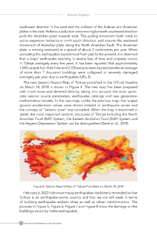
The new Seismic Hazard Map of Türkiye published in the Official Gazette
on March 18, 2018 is shown in Figure 4. The new map has been prepared
with much more and detailed data by taking into account the most up-to-
date seismic source parameters, earthquake catalogs and new generation
mathematical models. In the new map, unlike the previous map, the largest
ground acceleration values were shown instead of earthquake zones and
the concept of “seismic zone” was cancelled. When the map is examined in
detail, the most important tectonic structures of Türkiye including the North
Anatolian Fault (KAF) System, the Eastern Anatolian Fault (DAF) System and
the Aegean Depression System can be distinguished (Benli et al., 2018).
Figure 4. Seismic Hazard Map of Türkiye Published on March 18, 2018
February 6, 2023 Kahramanmaraş earthquakes has bitterly reminded us that
Türkiye is an earthquake-prone country and that we are still weak in terms
of building earthquake-resilient cities as well as urban transformation. The
pictures in Figure 5, Figure 6, Figure 7 and Figure 8 show the damage on the
buildings struck by these earthquakes.
300 The Journal of Environment, Urban and Climate